Last Update: December 15, 2015 |
Dialog Help
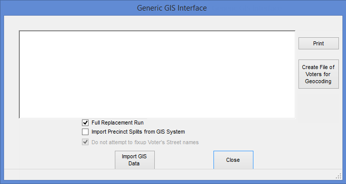
To access: STREETS AND PRECINCTS > Street Utilities > Export/Import Data via Generic GIS Interface
On this dialog, you can create a file for GIS geocoding and import the results of geocoding from a file created on the GIS system.
Fields and Controls on this Dialog
Prints a PDF of the messages shown in the pane during an import from the GIS system. |
|
Create File of Voters for Geocoding |
Extracts voter demographic and street-address data into a file that can then be read by a GIS system. |
Full Replacement Run |
Select to replace the existing Streets table (Streetm) in the voter registration database with the data from the GIS import file. The run also clears the street-audit table (Streeta). Note Full replacement runs on the production database must be done when the system is quiet. To do an incremental update, which processes only the changes to the streets table, rather than replacing the table, leave this option blank. Note Incremental updates are not permitted when more than five percent of rows in the streets table are affected. |
Import Precinct Splits from GIS System |
If you select Full Replacement Run, this option is enabled. Leaving this option blank lets you determine if precinct splits were created in the GIS system and are therefore contained in the import file, because any new precinct split in the import file will cause the import process to generate an error message. |
Do not attempt to fixup Voter's Street names |
Normally, the full replacement run performs a check for street name changes, comparing those in the Voter Focus database with street names in the import file. If there are differences, the database is updated with the names in the import file. Records of affected voters are also updated. This option tells the import run to omit the check for street name changes. This option should be selected during redistricting, because changes to street names can complicate the troubleshooting of issues with redistricting. Any changes to street names should be done before or after the redistricting effort. |
Import GIS Data |
Start the import process. You will be asked for the path name of the import file. For a description of what occurs during an import, see Running_the_Import. |
Close |
Close the dialog. |